Standardised surveys of highly mobile biota in remote areas is demanding at the best of times – often difficult, tedious and subject to the vagaries of time, weather and resourcing. Long term monitoring data consisting of repeated counts of landscapes over life times and generations of organisms in the wild is one of the gold standards in wildlife ecology – often hoped for but rarely achieved, especially at large spatial scales. Adding to the challenges, there is a need to maintain consistency in collection, collation and curation of data, ensuring it is also publicly available.
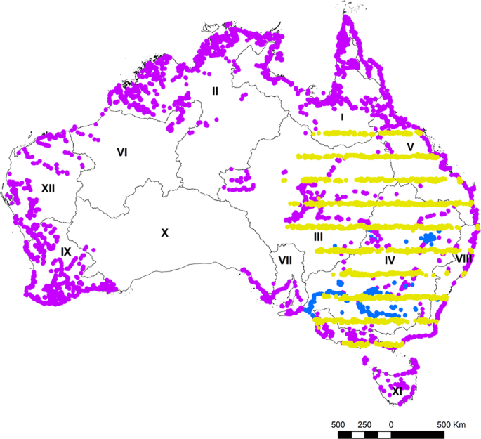
We have monitored waterbirds regularly over about a third of the Australian continent for decades (37 years; Fig.1). This has provided unique insights into natural cycles but also the effects of humans on waterbird populations and their wetland habitats.

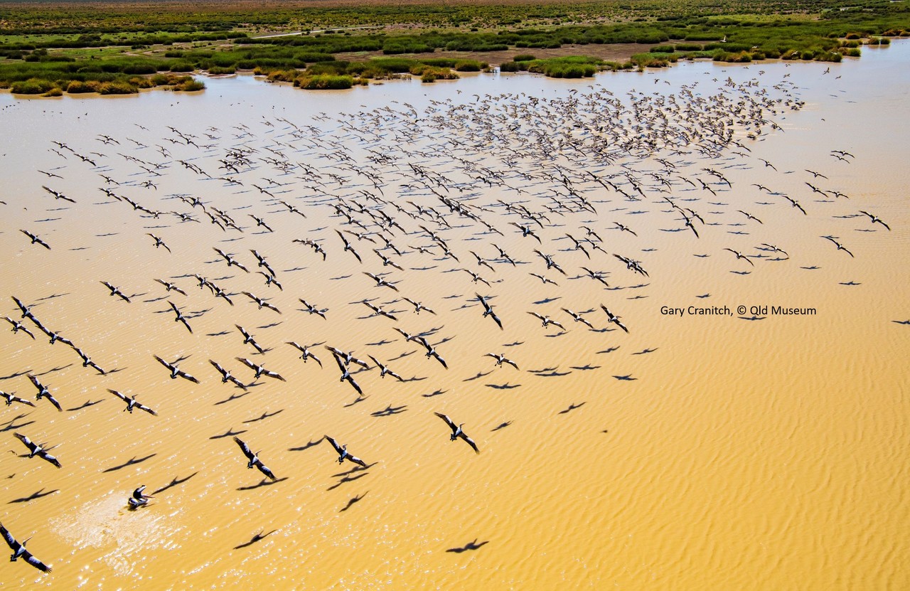
It is thrilling to fly low over a wetland and count thousands of waterbirds, particularly over inland Australia and the tropics. The sight of so many waterbirds of different species concentrated in wetlands and rivers is spectacular (Figs 2 & 3). Added to this, our knowledge and understanding of changes in freshwater environments is increasing all the time, with each year of data. Waterbird species cover the range of niches provided by wetlands, given the diversity of diets, from fish-eating pelicans, herbivorous black swans and invertebrate feeding shorebirds.

We are excited to provide this database of annual aerial counts of waterbirds, – the Australian Aerial Waterbird Surveys database. It stores and provides access to count data of individual waterbird species, their breeding status and their wetland habitat areas, collected during our annual aerial surveys, extending back to 1983. The database contains 23,367 discrete counts of up to 109 waterbird species on 22,587 unique wetland locations.
The Australian Waterbird Surveys database, just published in Scientific Data (https://doi.org/10.1038/s41597), includes three main survey programs: the Eastern Australian Waterbird Survey, the National Waterbird Survey and surveys of the major wetland sites in the Murray-Darling Basin. Since 1983, the Eastern Australian Waterbird Survey has covered about a third of the continent each October, representing one of the larger and longer running biodiversity surveys in Australia, sampling wetland and waterbird communities across 2.7 million km2 of eastern Australia. In 2008, a relatively dry year, we did aerial surveys over most large wetlands across Australia, during a period of two months. And since 2010, we have comprehensively surveyed all the major wetlands in the Murray-Darling Basin.

The Australian Waterbird Surveys database provides some of the only long-term objective data on waterbird populations in Australia. This has proved particularly relevant in understanding the dynamics of natural flooding and drying processes, particularly of temporary wetlands but also the effects of water resource environmental water needs for biodiversity purposes especially as they relate to waterbirds and wetlands. Changes in waterbird numbers provides a tangible way of indicating and measuring changes in the ecological health of river and wetland systems.
Tracking waterbird populations has allowed us to understand changes at ecosystem level, including water management, environmental flow management, migratory species, areas of outstanding biodiversity and threatened species management. This has included large wetland systems such the Macquarie Marshes, Menindee Lakes and Lowbidgee floodplain wetlands. Our data has also been instrumental in identifying wetlands of national and international importance, including the Paroo River and Cooper Creek wetlands.
We hope to continue to do our surveys and improve our understanding of these systems as well as track environmental change.


Please sign in or register for FREE
If you are a registered user on Research Communities by Springer Nature, please sign in